Experience
Massachusetts Development Finance AgencyGIS Specialist
07/2022 - present
- Responsible for design, administration, maintenance, and updating of Devens GIS and CAD, as well as other various agency projects. Primary functions include maintaining Municipal files such as address, parcel, and utility data as well as GPS data collection
- Conduct exploratory and spatial analysis and provide training on GIS interfaces and workflows for non-GIS staff
- Develop high-quality cartographic visualizations, assist other departments with related tasks and interface with local, state, and federal agencies
- Collaborate with other agency divisions and departments such as Information Technology, Community Development, Marketing, various Assessor offices, Devens Fire Department, Devens Department of Public Works and Recreation, the Massachusetts State Police, and others
Founder/Head of GIS
11/2015 - present
- Owner and Operator of ClioGraphica, a Location Intelligence Firm which aims to provide geospatial intelligence consulting services for non-profits organizations, client businesses, and municipalities
- (Municipal) Map Maintenance: mapping services for tax assessor, zoning, parks and recreation, conservation, environmental resources, and historic commission
- GIS Support for (Municipal) Staff: providing (municipal) staff GIS training, ongoing technical support, and project outsourcing
- Database Management and Administration: maintain (municipal department) databases, inputting field data, and generating reports using SQL
- Asset ID and Strategic planning: helping (municipal) decision makers formulate strategic growth plans by providing analysis on their location based data
- Mobile Application development: creating user friendly interfaces for custom data gathering tools for staff operating in the field, and applications for residents to communicate with their municipality
- Desktop Application development: creating standalone desktop applications to help staff streamline workflow and process/archive data
- Client Reviews: Claudia Wolen, Education Coordinator, Stamford Historical Society
GIS, Geospatial, History, and Digital Humanities Tutor
10/2014 - present
- Student Projects
- Tutor graduate and undergraduate level GIS practices, system and database administration, and geospatial analytics
- Graduate and undergraduate level history tutor - focus on analytical writing and Digital Humanities research
GIS Technician I: Electric Utility GIS
12/2019 - 07/2022
- Specializations:
- Electric Vehicle Infrastructure Mapping
- -Contributed to reference material for mapping protocol
- -Coordination with Distribution Transportation team for mapping requirements
- Advanced Distribution Management System (ADMS) Team
- -Quality Control of GIS and Electric Distribution Grid Data
- -ADMS provides our distribution control centers with new visibility and advanced capabilities to monitor and control the electric distribution grid. This includes enablement of advanced functionality of Fault Location, Isolation and Service Restoration that when enabled provides outage location prediction and enhanced outage response
- -ADMS also provides near real-time solutions that enable Xcel Energy to support increased demand and integration of distributed generation from clean energy sources
- Electric On Hold Work Order processing
- -Proficiency with utility operations software SAP, BUD, Oracle NMS, and CRS to review business and customer relations
- -Rectify GIS mapping errors based on company documents and field collected data
- -Outreach with field crews to obtain missing information
GIS Analyst
10/2018 - 06/2019
- GIS department, Telecommunications Division
- Low Level Design (LLD) drafting using ArcGIS 10.6.1 and AutoCAD Map 3D
- Training and assisting supporting staff and team members
- Construction staking sheets production for fiber optic cable networks
- Implementation of data driven pages, database creation and organization, cartographic design, and team coordination
Geospatial Research Associate
01/2018 - 10/2018
- Social Sciences GIS Analyst with Critical Health and Social Ecology Lab in Psychology Department of Wesleyan University
- GIS analysis of psychological data sets allows our lab to spatially analyze the distribution of responses to survey questions gauging participants' social well being, community connection, physical health, etc.
- Developed and presented workshops for our lab as well as undergraduate psychology research classes, "Introduction to GIS: Workshop for Interdisciplinary Social Sciences Research"
- Work directly with students interested in GIS projects on campus. Provide tutoring services as well as connecting students with resources on campus and online
- In development of Web Mapping Service to display lab data, as well as host data online and provide links to our website for students to download directly
- Ten ft. by five ft. vynal map of Transatlantic Slave Trade
Campaign Manager and Geospatial Consultant
08/2017 - 11/2017
- While campaign manager I coordinated events, outreach, volunteers, and research. This included using the DNC VoteBuilder platform to organize lists of people to contact through phonebaking and canvasing
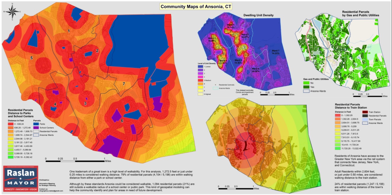
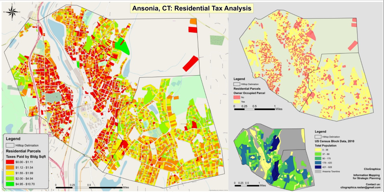
- Campaign Maps
- As the Geospatial Consultant, I provided maps and spatial analysis which contributed to the policy research and platform messages of our campaign. Examples of these analyses include number of residential parcels within "walking-distance" to parks and school centers, density of dwelling units, distribution of residential taxes paid by building square foot, population distribution, and proposals for bus stop locations which would be within walking-distance to over 90% of residential parcels in town
GIS Manager
09/2016 - 01/2017
- Managed HVA’s GIS department which works in coordination with internal departments (i.e. Watershed Planning Department and field crew) and external clients such as local municipalities, land trusts organizations, and individuals seeking GIS analysis or general mapping services. Common GIS projects included multi-variable site selection analysis, environmental/natural resources modeling, parcel editing, and geospatial database creation. Re-organized/centralized company GIS for greater efficiency among workgroup of GIS users at main office
- Facilitated the development of regional and local geospatial datasets, managed the collection, formatting, and assimilation of various demographic/environmental/natural resource/geospatial data from a variety of sources – including the creation of data by field sampling
- Maintained online GIS platforms (ArcGIS for Server Enterprise, ArcSDE, ArcGIS Online, App Studio for ArcGIS) consisting of HVA created regional datasets. Before leaving, I was in the process of creating mobile Geo-applications for “reporter” and “tour” type function. Updated, revised, and created new Web Mapping Services and Web Applications for regional conservation initiatives
Digital Humanities Researcher, GIS Specialist
10/2013 – 05/2016
- Functioned as a geographic information specialist for Virtual Hartford, a team of graduate and undergraduate students who are constructing an educational website dedicated to historical Hartford, CT
- Researched, processed, and integrated relevant data to create dynamic cartographic representations of Virtual Hartford research projects
Intern in Planning Department, GIS Specialist
09/2015 - 12/2015
- Worked in Land Use and Planning Department on geographically diverse projects throughout Fairfield County, CT
- Utilized GIS to create maps of property with accompanying research
- Researched land records and legal regulations pertinent to client properties in effort to draft regulation variances or project proposals
Student Administrator
05/2014 – 05/2015
- Organized and maintaind museum client files regarding different sponsored events
- Proofread and peer-reviewed museum publications
Research Assistant, Online GIS Specialist
09/2014 – 12/2014
- In collaboration with the Map and Geographic Information Center and Connecticut State Data Center, I developed an online interface to house and display data of the office of the Connecticut State Archaeologist
- Mapped Archeological data using Google Fusion Tables platform
- Worked directly with CT State Archeologist, Brian Jones
Researcher, GIS Analyst, led by Professor Ouimet
06/2014 – 12/2014
- Study the history, mechanics, and evolution of landscapes at human timescales
- Leveraged ArcGIS software and LiDAR data to construct Digital Elevation Models (DEMs) to identify, geoprocess and map charcoal hearths as part of an investigation pertaining to historical Connecticut geography
- Click here for a link to Patrick Skahill’s interview of lead professor William Ouimet on wnpr
Census and Geospatial Data Assistant, Enterprise GIS Analyst, Historical GIS Specialist, GIS Analyst
10/2013 – 06/2014
- Functioned as Enterprise GIS analyst in an office which contracted state-wide geospatial data projects
- Focused on researching maps and associated textual documentation, georeferencing these maps to create workable primary source material for students studying Digital Humanities, creating metadata for georeferenced maps and datasets, and heads-up digitizing derivative data for historical analysis
- Utilized ArcGIS and census data to construct historical GISystems and maps for Virtual Hartford
Junior Accountant
2009 – 2011
- Processed tax returns, book-keeping for individuals and businesses, and office/file maintenance
Professional Certifications
Certified Geographic Information Systems Professional (GISP)- Issued by Geographic Information System Certification Institute (GISCI): December, 2023
- GISP Registry Credential ID: 161719
Education
BA History, GISUniversity of Connecticut, College of Liberal Arts and Sciences
Fall 2015
- Bachelor of Arts in History, Geographic Information Systems/Sciences (GIS) minor
- Honors Thesis: ClioGraphy, Historical Geospatial Analysis (under edit)
University of Vermont
Attended: 2011-2012
Westhill High School
Spring 2011
- Member and graduate of the Academy of Finance: Member of the Future Business Leaders of America (FBLA)
Honors
University of Connecticut- University of Connecticut Honors Scholar Program: March, 2014 - December, 2015
- Phi Alpha Theta History Honors Society: Inducted May, 2014
Scholarships and Research Grants
William P. O'Hara Endowed Scholar- Awarded scholarship for demonstrating an interest in music and having a record of academic achievement
- Awarded grant funding travel to present research at the Association for the Study of Connecticut History (ASCH) Conference: Fairfield University (April 5, 2014) IDEA Grant Recipient
- Awarded competitive grant to fund self-directed and self-developed research regarding digitization, demographic modeling, and Historical GIS
Academic Conferences
UConn Frontiers Poster ExhibitionAuthor, Presenter
04/10/2015
- Presented IDEA Grant research at UConn exhibition of undergraduate research and achievement
- Focused on research findings and methodology of Historical GIS case study
Panel Member, Presenter
02/16/2015
- Presented my self-developed interdepartmental on-campus internship experience and the potential benefit of exploring research projects through internships
- Focused on the significance of student self-advocacy
- Collaborated with University of Connecticut’s Center for Career Development to promote and facilitate undergraduate on-campus internships, with a focus on inter-departmental collaborations and self-created opportunities that enhance deep and authentic learning experiences
Co-author
Spring 2015
- Presented by colleagues Professor William Ouimet and Graduate student Kate Johnson of the UConn Department of Geography & Center for Integrative Geosciences
- Conducted Geospatial and LiDAR-based analysis of 18th to early 20th century timber harvesting and charcoal production in southern New England to generate data for further study of Connecticut Geomorphology
Co-author
Fall 2014
- Presented by colleague Michael Howser – Director of Connecticut State Data Center at UConn
- Discussed our on-campus internship initiative and the benefits of interdepartmental collaboration such as deep and authentic learning
Author, Presenter
05/13/2014
- Presentation title: Historians to Geographers: Using Maps to Illustrate Hartford’s Cultural Heritage
- Abstract: Hartford’s rich cultural heritage involves a number of events which have a spatial connection, a connection which is illustrated with the Virtual Hartford project. This presentation will explore ideas and concepts that connect history with spatial location using maps, archives, and content. Utilizing collections from the Hartford History Center, Connecticut Historical Society, and the UConn Libraries MAGIC, this project connects archival content to maps to enable student and prospective researchers to reinterpret the history of Hartford, CT based on primary sources. Join us as we explore how to leverage ArcGIS, Google Maps, and Omeka Neatline to connect users with primary sources based on locations in Hartford, Connecticut.
Author, Presenter
04/05/2014
- Presentation title: Virtual Hartford: Interactive Microhistories and the Digital Humanities
- Discussed the viability of incorporating GIS analysis into a humanities focused historical analysis
Interests and Activities
AcademicVolunteer mapper with Humanitarian OpenStreetMap Team, Digital Humanities history, Historical Geography, GIS, Historical GIS, Cliography, Cartography, Historiography, Pre/Ancient/Classical history, Cultural history, history of religion and effect on social development with a focus on history of Graeco-Arabic Translation Movement (2CE – 10CE)
RecreationalCrafts and outdoors: Fishing, hiking, camping, wood-working, metal-working; Music: drums, trumpet, guitar, banjo, harmonica, mouth harp, tin whistle; Martial arts: Brazilian Jiu-Jitsu, Krav-Maga, And Tae Kwon Do